


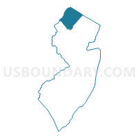
Sussex County PUMA, New Jersey
About
Outline

Summary
| Unique Area Identifier | 193405 |
| Name | Sussex County PUMA |
| State | New Jersey |
| Area (square miles) | 535.74 |
| Land Area (square miles) | 519.01 |
| Water Area (square miles) | 16.73 |
| % of Land Area | 96.88 |
| % of Water Area | 3.12 |
| Latitude of the Internal Point | 41.13742390 |
| Longtitude of the Internal Point | -74.69185450 |
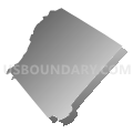
Maps

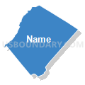
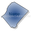
Graphs
Select a template below for downloading or customizing gragh for Sussex County PUMA, New Jersey


Neighbors
Neighoring Public Use Microdata Area (by Name) Neighboring Public Use Microdata Area on the Map
- Monroe County PUMA, PA
- Morris County (North)--Dover Town & Kinnelon Borough PUMA, NJ
- Morris County (West) PUMA, NJ
- Orange County (Northwest) PUMA, NY
- Orange County (Southeast) PUMA, NY
- Passaic County (North)--Ringwood, Wanaque & Pompton Lakes Boroughs PUMA, NJ
- Pike, Wayne & Susquehanna Counties PUMA, PA
- Warren County PUMA, NJ
Top 10 Neighboring County (by Population) Neighboring County on the Map
- Passaic County, NJ (501,226)
- Morris County, NJ (492,276)
- Orange County, NY (372,813)
- Monroe County, PA (169,842)
- Sussex County, NJ (149,265)
- Warren County, NJ (108,692)
- Pike County, PA (57,369)
Top 10 Neighboring County Subdivision (by Population) Neighboring County Subdivision on the Map
- Warwick town, Orange County, NY (32,065)
- Mount Olive township, Morris County, NJ (28,117)
- West Milford township, Passaic County, NJ (25,850)
- Vernon township, Sussex County, NJ (23,943)
- Roxbury township, Morris County, NJ (23,324)
- Jefferson township, Morris County, NJ (21,314)
- Sparta township, Sussex County, NJ (19,722)
- Middle Smithfield township, Monroe County, PA (15,997)
- Hopatcong borough, Sussex County, NJ (15,147)
- Dingman township, Pike County, PA (11,926)
Top 10 Neighboring Place (by Population) Neighboring Place on the Map
- Hopatcong borough, NJ (15,147)
- Lake Mohawk CDP, NJ (9,916)
- Port Jervis city, NY (8,828)
- Newton town, NJ (7,997)
- Mount Arlington borough, NJ (5,050)
- Franklin borough, NJ (5,045)
- Highland Lake CDP, NJ (4,933)
- Stanhope borough, NJ (3,610)
- Hamburg borough, NJ (3,277)
- Netcong borough, NJ (3,232)
Top 10 Neighboring Elementary School District (by Population) Neighboring Elementary School District on the Map
- Sussex-Wantage Regional School District, NJ (13,488)
- Byram Township School District, NJ (8,350)
- Hardyston Township School District, NJ (8,213)
- Blairstown Township School District, NJ (7,663)
- Andover Regional School District, NJ (6,925)
- Frankford Township School District, NJ (6,406)
- Hampton Township School District, NJ (5,196)
- Mount Arlington Borough School District, NJ (5,050)
- Franklin Borough School District, NJ (5,045)
- Allamuchy Township School District, NJ (4,323)
Top 10 Neighboring Secondary School District (by Population) Neighboring Secondary School District on the Map
- High Point Regional School District, NJ (22,432)
- Wallkill Valley Regional School District, NJ (18,945)
- Lenape Valley Regional School District, NJ (15,192)
- Kittatinny Regional School District, NJ (14,746)
- North Warren Regional School District, NJ (12,948)
Top 10 Neighboring Unified School District (by Population) Neighboring Unified School District on the Map
- East Stroudsburg Area School District, PA (47,915)
- Delaware Valley School District, PA (29,140)
- Mount Olive Township School District, NJ (28,117)
- West Milford Township School District, NJ (25,850)
- Vernon Township School District, NJ (23,943)
- Warwick Valley Central School District, NY (23,647)
- Roxbury Township School District, NJ (23,324)
- Minisink Valley Central School District, NY (23,035)
- Jefferson Township School District, NJ (21,314)
- Sparta Township School District, NJ (19,722)
Top 10 Neighboring State Legislative District Lower Chamber (by Population) Neighboring State Legislative District Lower Chamber on the Map
- General Assembly District 23, NJ (229,972)
- General Assembly District 26, NJ (217,839)
- General Assembly District 25, NJ (215,844)
- General Assembly District 24, NJ (215,703)
- Assembly District 97, NY (144,514)
- Assembly District 98, NY (138,734)
- State House District 189, PA (76,401)
- State House District 139, PA (67,006)
Top 10 Neighboring State Legislative District Upper Chamber (by Population) Neighboring State Legislative District Upper Chamber on the Map
- State Senate District 38, NY (347,376)
- State Senate District 42, NY (313,027)
- State Senate District 20, PA (273,416)
- State Senate District 23, NJ (229,972)
- State Senate District 26, NJ (217,839)
- State Senate District 25, NJ (215,844)
- State Senate District 24, NJ (215,703)
Top 10 Neighboring 111th Congressional District (by Population) Neighboring 111th Congressional District on the Map
- Congressional District 19, NY (699,959)
- Congressional District 11, PA (687,860)
- Congressional District 11, NJ (674,349)
- Congressional District 10, PA (669,257)
- Congressional District 5, NJ (666,551)
Top 10 Neighboring Census Tract (by Population) Neighboring Census Tract on the Map
- Census Tract 461.06, Morris County, NJ (7,616)
- Census Tract 3718, Sussex County, NJ (7,407)
- Census Tract 3734, Sussex County, NJ (6,731)
- Census Tract 3731, Sussex County, NJ (6,206)
- Census Tract 9506.06, Pike County, PA (6,079)
- Census Tract 447.02, Morris County, NJ (6,004)
- Census Tract 311.01, Warren County, NJ (5,976)
- Census Tract 446.02, Morris County, NJ (5,734)
- Census Tract 145.02, Orange County, NY (5,435)
- Census Tract 3715.02, Sussex County, NJ (5,399)
Top 10 Neighboring 5-Digit ZIP Code Tabulation Area (by Population) Neighboring 5-Digit ZIP Code Tabulation Area on the Map
- 07860, NJ (26,288)
- 07871, NJ (21,165)
- 10990, NY (20,631)
- 07461, NJ (19,563)
- 18302, PA (17,362)
- 18337, PA (14,572)
- 12771, NY (14,511)
- 07828, NJ (14,150)
- 07843, NJ (12,241)
- 07438, NJ (11,559)